Geography
Elementary Survey And Map Making
Reading settings
Text size
Line spacing
Colours
Geography is the study of places and the relationship between people and their environment. Geographers explore both the physical properties of the Earth's surface and the human societies spread across it.In the context of dynamic and changing world, it is very crucial to study Geography so as to be able to achieve sustainable human development.
Elementary Survey And Map Making
Introduction
In this topic, you will learn about the types of survey, purpose of elementary survey, equipments used to carry-out survey, procedures that need to be followed and the importance of chain survey
Objectives
By the end of this topic you should be able to explain the meaning of simple land survey, explain the types of simple land survey and describe chain/tape survey, explain different types of equipments used in chain/tape surveying, practise chain/tape surveying activities at the school level and explain the importance of survey
Meaning and Types ofSurvey
Simple Land Survey
Explain the meaning of simple land survey
Surveying or land surveying is the science of gathering, examining, recording and measuring the area of land and features on, above and below the Earth’s surface. During land surveying, normally various measurements are taken. They include lengths, angles and heights. The results obtained from these measurements provide the data required for making plans and maps, and determining distances, areas, volumes and other related quantities.
Angular measurement is taken by measuring the distance from a given reference point to an observed object. This distance is measured in a clockwise direction from North. Linear measurement is the distance measured along the surface of the ground such as a horizontal distance.
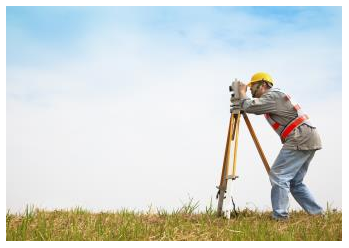
The drawing of a map on any flat surface, such as piece of paper, showing the size and spatial distribution of various features depends on actual surveying of the mapped area. Likewise, construction of various structures such as roads, railways, and buildings involves surveys. Surveying of the area where these structures are to be built is done before construction work is undertaken.
Purposes of surveying include the following:
- To prepare maps and plans.
- To calculate areas and distance.
Types of Simple Land Survey
Explain the types of simple land survey
Surveying can be categorized into various types or branches depending on its purpose, function and nature
Chain Survey
Chain/Tape Survey
Describe chain/tape survey
Chain or tape survey is a method of surveying in which no angles are measured but only linear measurements are taken in the field by using a chain or tape measure. In this survey, measurements are taken in the field, and the rest of work, such as plotting, calculation etc. is done in the office.
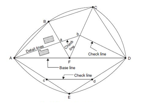
Chain survey involves the use of triangles except where the land being surveyed forms a complete rectangle upon which the detail is built. It is a very simple method used for surveying small areas on grounds that offer little obstruction to linear measurements.
It is also used to fill in details on a map whose larger features have been surveyed by other methods such as aerial survey. If carefully done, it gives quite accurate results.
Types of Equipment used in Chain/Tape Surveying
Explain different types of equipment used in chain/tape surveying
To conduct chain survey successfully, a number of different equipment is used. The equipment used in chain survey include the following:
(a) Chain
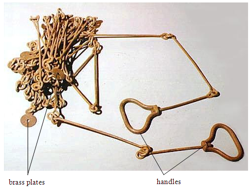
A chain is used to measure short, linear distances on the field. It is made up of connected steel segments, or links, each with a length of 20 cm. Sometimes brass plates are attached at every 5 m length to serve as joint or tally markers. A chain can be 20, 25 or 50 metres long, including one handle at each end.
(b) A tape
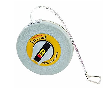
Measuring tapes or tape measures are made of steel, coated linen, or synthetic material. They are available in lengths of 20, 30 and 50 m. Centimetres, decimetres and metres are usually indicated on the tape. Just like chains, tapes are used to measure short, straight distances.
(c) Measuring rod
A measuring rod is a straight piece of wood with a length varying from 2 m to 5 m. The rod is usually marked in the same way as a measuring tape, indicating centimetres, decimetres and metres. The rod is used for linear measurements.

(d) Plumb line
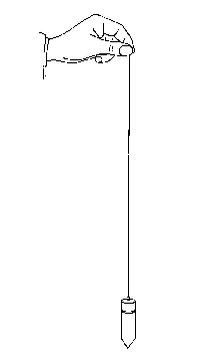
A plumb line is used to check if objects are vertical. A plumb line consists of a piece of metal (called a plumb bob or plummet) pointing downwards, which is attached to a string. When the plumb bob is hanging free and not moving, the string is vertical.
(e) Spirit level
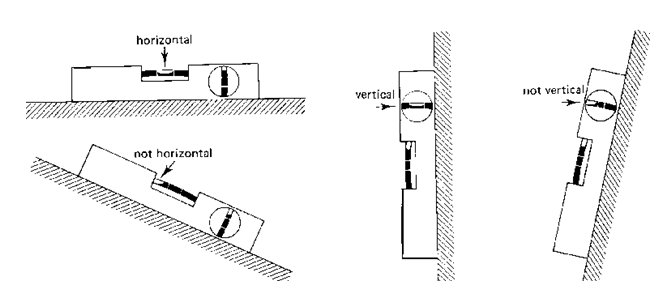
A spirit level, also known as carpenter level, is used to check if objects are horizontal or vertical. Within a spirit level there is/are one or more curved glass tube(s), called level tube(s).

Each tube is sealed and partially filled with a liquid (water, oil or paraffin). The remaining space is air, visible as a bubble. On the glass tube there are two marks. Only when the spirit level is horizontal (or vertical) is the air bubble exactly between these two marks (Fig. 4.8).
(f) Ranging poles
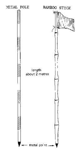
Made up of wood or light metal, ranging poles are used to mark stations and to set out straight lines on the field. They are also used to mark points which must be seen from a distance, in which case a flag may be attached to improve the visibility.
Ranging poles are straight, round stalks, 3 to 4 cm thick and about 2 m long. They are made of wood or metal with pointed steel heads for sticking into the ground. Ranging poles can also be home-made from strong, straight bamboos or tree branches.
Remember that ranging poles may never be curved. Ranging poles are usually painted with alternate red-white or black-white bands so that they can be easily seen even from a distance. If possible, wooden ranging poles are reinforced at the bottom end by metal points.
(h) Pegs
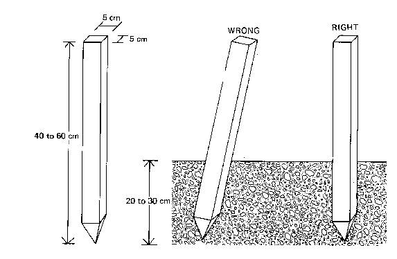
Pegs, generally made of wood, are used for permanently marking positions during survey. Sometimes pieces of tree branches, properly sharpened, are good enough. The size of the pegs (40 to 60 cm) depends on the type of survey work they are used for and the type of soil they have to be driven in. The pegs should be driven vertically into the soil and the top should be clearly visible.
(i) Arrows
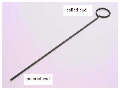
Arrows are made of steel wire of diameter 4 mm. They are used for marking the end of each chain length during the process of chaining. The arrows are pointed at one end and coiled or rounded at the other end where a rag or tag can be tied to make them more visible.
(j) Cross staff
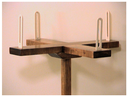
This is a cross fitted on a short ranging pole used for setting out right angles from the line. It can be made of wood or steel and has eye slits at right angles.
(k) Optical square
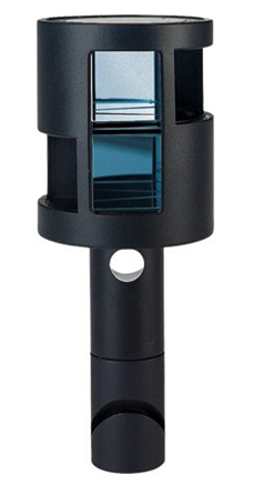
An optical square is a hand-held instrument used to set out right angles. It employs two mirrors at a 45° angle. It is used for marking offsets at right angles from the line. The term offset refers to the lateral distance of an object or ground feature measured from a survey line.
(l) Field notebook
A notebook is used for recording all necessary field work information.

(m) A hard pencil and a rubber
Hard pencils are used for drawing in the field and a rubber is used to erase mistakes or errors which are made. A pencil should be HB or HHB.
The other equipment used in chain survey include a compass and surveyor’s band.
Chain/Tape Surveying Activities at School Level
Practice chain/tape surveying activities at school level
Chain survey, as a science and art, is conducted by adhering to certain procedures for the best outcome. The entire operation of chain survey can be divided into three major groups namely, an inspection of the area, surveying in the field and presentation of data or recording
1. Inspection of the survey area (Reconnaissance)
The preliminary inspection of the area to be surveyed is called reconnaissance. The first step in conducting a survey is to inspect the area to be surveyed. This includes preparing index sketch or key plan. Note details like roads, buildings, canals, ditches, culverts and the difficulties and obstacles that may arise during survey.
It is important to give a north line on the rough sketch and though the sketch is not prepared according to the scale, it should represent the approximate positions of the different things in the plot and hence to be a good guide for further work.
Inspection of the site for survey may involve the following:
- Walk over and inspect the area to be surveyed and thoroughly examine the ground, note the position of boundaries, road, and river etc., and various obstacles to chain lines. Prepare neat sketches called index sketches or key plan.
- Estimate the maximum dimensions of the survey area, either by rough tape measuring or by pacing. This will help when working out the scale.
- Select survey stations and survey lines: Stations are points on the ground fixed by driving pegs. Every station should be located with respect to three permanent objects i.e. the distances from these objects to the stations should be measured very accurately and recorded in the field book. The advantage of taking this measurement is that if in future the peg at the station is lost, then it can be located again by knowing descriptions and distances of these objects.
The selection of a particular station depends upon the fallowing important considerations:
- The triangle should be a well-defined one, i.e. nearly equilateral triangle.
- There should be a minimum number of obstacles in ranging and chaining.
- The chain line should run near the boundary of the plot.
- Offsets should not exceed one chain.
- Check and tie lines should be provided in sufficient number so that all the main lines, offsets and other details can be checked thoroughly.
- Adjacent stations should be intervisible so that ranging can be done easily.
- Make sure lines joining adjacent stations pass through a level open ground as far as possible so that chaining can be done easily.
- Survey lines should be as few as possible so that framework of triangles can be plotted easily. The lines are sited where they can be used to pick as much detail as possible.
- Ensure distances between station points are known (can be measured using chain or tape and recorded on a field book).
- Stations should be recorded by assigning them numbers or letters for identification.
- The main survey lines should form well conditioned triangles with no angles less than 30° or more than 120°.
A tie line is one which connects two points on the two main lines of the triangle. It helps in taking offsets of the objects falling within the triangle and which are too far away from the main line.
A check line is also a tie line which helps in checking the accuracy of the work after plotting in a drawing sheet. A check line or tie line is never extended beyond the main lines.
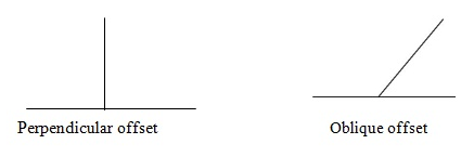
An offset is the lateral distance of an object or ground feature measured from a survey line. The two types of offsets are:
- Perpendicular offset: The angle of offset from a point on a chain line is 90º.
- Oblique offset: When the angle of offset is other than 90º.
2. Surveying in the field
A survey team involves three people, the leading chainman or leader, the follower and the booker. The follower is in charge of measurements while the booker records all data in the field notebook. The chain is thrown to extend it and disentangle any knots. The leader takes ten arrows and a ranging rod, and the follower takes a ranging pole. The follower erects his ranging pole at the first base point and places a brass handle of the chain against the ranging pole. A leader straightens the chain and inserts an arrow at the other end of the brass handle. Offsets and tie lines can now be taken. The leader drags the chain so that the follower’s end is on the leader’s arrow. The follower moves to another point and places his ranging pole behind the arrow. This procedure is then repeated as measurements are recorded by the booker.
Generally, during actual survey, the following should be observed:
- In the case of chaining along the road, it is always better to run chains on one side of the road to avoid interruptions by vehicles. It is better not to cross the road frequently.
- The frame should have at least one long baseline that runs through the middle of the area.
- If required, number of subsidiary stations should be selected and subsidiary lines run to avoid long offsets.
- While selecting main stations and survey lines, the basic principles of surveying involving working from whole to the part should be followed.
3. Presentation of data or recording
After the field has been surveyed, all the information gathered during the exercise (data) is recorded in a notebook. It presented in a manner that can be understood by others. The data is represented in the form of maps, plans, or diagrams. These are recorded on the drawings by:
- scale presentation;
- use of conventional signs;
- tabulation of notes; or
- measured and calculated data.
The best method chosen depends on the nature of the survey work.
The Importance of Survey
Explain the importance of survey
Land surveying is a very important profession for social and economic development. The points below describe the importance of land survey.
- It is important in land use planning, which includes town mapping, civil engineering, structural engineering, and architecture.
- It is used to fill in details on a map whose large features have been surveyed by other methods.
- It is used in mapping small areas of flat or near-flat ground and associated objects, for example paths, roads and railways.
- It is used in adding detail to existing plans or large maps.
- It helps to find the relative positions and sizes of features on the land surface.
TOPIC SUMMARY
- Surveying or land surveying is the science of gathering, examining, recording and measuring the area of land and features on, above and below the Earth‘s surface.
- The purposes of surveying include preparing maps and plans and calculating areas and distance.
- Two broad types of simple land survey are plane surveying and geodetic surveying.
- Plane surveying or geodetic surveying may be further classified into the following categories:
- As-built survey
- Cadastral or boundary surveying
- Engineering surveying
- Structural surveying
- Topographic surveying
- Chain or tape survey is a method of surveying in which no angles are measured but only linear measurements are taken in the field by using a chain or tape measure.
- Equipments used in chain surveying are chain, tape, measuring rod, plumb line, spirit level, ranging poles, pegs, arrows, cross staff, optical square, field notebook, and pencil and rubber.
- Chain surveying is important in land use planning, filling in details on a map, mapping small areas, adding detail to existing plans or large maps, and helping to find the relative positions and sizes of features on the land surface.
- The procedures for chain survey include the following:
- Inspection of the survey area (reconnaissance)
- Surveying in the field
- Presentation of data or recording
REVIEW QUESTIONS
Question Time 1
A. 1. An offset is a (n) ___ distance of an object measured from survey line.
- Lateral
- Horizontal
- Normal
- Inclined
2. The process of location of intermediate points on a survey line is called___.
- Aligning
- Extending
- Ranging
- Offsetting
3. The book in which chain measurements are entered.
- Field book
- Record book
- Study book
- Chain book
4. Survey stations may be marked on the ground using a___.
- Pole
- Pointer
- Rod
- Peg
5. Chain surveying uses the principle of___.
- Traversing
- Chaining
- Ranging
- Triangulation
6. Which of the following is NOT one of the purposes of survey?
- To calculate areas and distance
- To mark boundaries of administrative regions
- To establish properties of the soil
- To prepare maps and plans
7. A type of survey that puts the curvature of the Earth into consideration.
- Plane survey
- Compass survey
- Levelling
- Geodetic survey
8. A survey carried out for the purpose of establishing the boundary of a village is called ___.
- Village survey
- Cadastral survey
- Plane survey
- Frontier survey
9.Which instrument is NOT used for measuring linear distances?
- Measuring rod
- Chain
- Tape
- Plumb line
10. Geodetic survey is done on a large area greater than ___ km2
- 100
- 25
- 500
- 250
B. State the difference between the following
- Geodetic surveying and plane surveying.
- Chain and tape measure.
- Arrows and pegs.
- Measuring rod and ranging pole.
11. What is triangulation as used in chain surveying?
12. Describe the different ways of taking measurements in chain surveying.
13. Explain the social and economic importance of chain surveying.
B. Match items in list A with those in list B by writing the letter of the correct counterpart against given numbers
| Column A | Column B | ||
| 1 | Plane surveying | A | Structural survey |
| 2 | Serves construction projects | B | Tape |
| 3 | A survey carried out during or immediately after a construction project | C | Topographic surveying |
| 4 | Made up of connected steel segments, or links | D | Setoff |
| 5 | Done in order to familiarize with survey area | E | Does not consider the curvature of the Earth |
| F | Chain | ||
| G | Optical square | ||
| H | As-built survey | ||
| I | Reconnaissance | ||
| J | Considers curvature of the Earth | ||
| K | Engineering surveying 3.Define the following terms | ||
| L | Surveying | ||
| M | Chain survey | ||
| N | Topographical surveying | ||
| O | Cadastral surveying |
REFERENCES
- Joseph, W.N. (2004). Contemporary Approach to Ordinary Level Geography. Afroplus Industries Ltd. Dar es Salaam.
- Kamili, Z. (2016). Practical Geography Alive. Kamili Books and General Supplies. Dar es Salaam.
- Mzezele, S. and Kibuuka, P. (2014). Geography In Focus Form Three. Oxford University Press Ltd. Dar es Salaam.
- Prichard, J.P. (1994). Practical Geography for Africa. Longhorn Publishers. London.
- Tanzania Institute of Education (1999). Geography Course Book for Secondary Schools Book Three. Ecoprint Ltd. Dar es Salaam
Listening to this topic