Geography
Forces That Affect The Earth
Reading settings
Text size
Line spacing
Colours
Geography is the study of places and the relationship between people and their environment. Geographers explore both the physical properties of the Earth's surface and the human societies spread across it.In the context of dynamic and changing world, it is very crucial to study Geography so as to be able to achieve sustainable human development.
Forces That Affect The Earth
Introduction
In this topic, you will learn about forces that affect the earth movements; internal forces, vulcanicity, Earthquakes, external forces, and artificial forces.
Objectives
By the end of this topic, students should be able to explain the forces which cause earth movements and their origin, describe the vertical/radial movement, identify the resulting features from the vertical movement, explain how horizontal movements take place, identify different features produced by horizontal forces, differentiate vulcanicity from volcanicity, explain causes of vulcanicity, volcanicity and the resulting features, classify features resulting from the processes of vulcanicity, locate the distribution of major volcanic zones in the world, assess the economic importance of volcanoes, define earthquake, epicentre and focus, describe how an earthquake can be detected, explain the causes and effects of earthquakes, locate the possible areas where the earthquake is likely to occur on a world map, define mass wasting and identify types of mass wasting, describe the factors which cause mass wasting, assess the effects of mass wasting on the environment, define the term weathering, identify types of weathering, differentiate weathering processes, assess the significance of weathering, define the concept of erosion and deposition, examine how agents of erosion and deposition operate on the landscape, examine erosional and depositional features for each agent, assess the importance of erosional and depositional features to human beings, explain the meaning of artificial forces which cause earth movements; and describe the causes and effects of artificial forces
Forces Causing Earth Movements
The Forces Which Cause Earth Movement and their Origin
Explain the forces which cause earth movement and their origin
The earth is affected by forces operating both within the earth‘s interior and on the earth‘s surface. The forces can be grouped into internal and external forces, which cause Earth movements. Earth movements are the powerful forces operating from within the earth‘s crust (lithosphere).
INTERNAL FORCES: Internal (tectonic) forces originate and operate in the interior of the Earth‘s crust. Internal forces operate through land-forming (endogenic) processes. These forces result in various Earth movements such as vertical and horizontal movements, vulcanicity and earthquakes.
EXTERNAL FORCES: These are natural forces that operate on the earth’s surface. The forces mainly act on the earth’s crust or close the surface of the earth. Often the features produced by these forces are seen on the surface of the earth. They include mountains, volcanoes, moraines and valleys, just to mention a few
Radial/Vertical Movement
The Vertical/Radical Movement
Describe the vertical/radical movement
These are up and down movements which cause the crustal rocks to fault. These movements result in a number of landforms such as plateaus, Block Mountains, rift valleys, basins, etc.
The Resulting Features from the Vertical Movement
Identify the resulting features from the vertical movement
Vertical earth movements: These are up and down movements which cause the crustal rocks to fault. These movements result to a number of landforms such as plateaus, block mountains, rift valleys, basins, etc.
Lateral or Horizontal Movement
How Horizontal Movements Take Place
Explain how horizontal movements take place
Lateral earth movements: These are sideways movements of the earth’s crust which cause the crustal rocks either to fold, fault or form joints. Features which are produced due to this movement are such as fold mountains, rift valleys, block mountains, etc.
Different Features Produced by Horizontal Forces
Identify different features produced by horizontal forces
Features associated with earth movements
Rift Valley
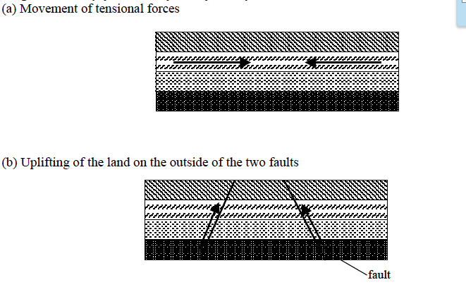
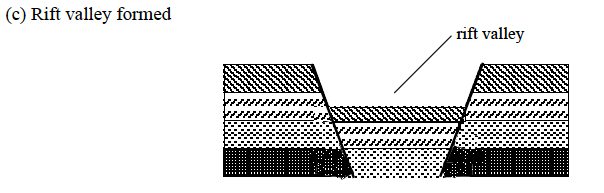
The rift valley is a trough or hollow resulting from both vertical and lateral movements of the earth‘s crust. It is formed when two faults develop parallel to each other. It can develop either by tensional forces or compressional forces.
Formation of rift valley by tensional forces
This is formed when tensional forces move away from each other. These forces of tension produce faults and the block between two parallel faults subsides to form a rift valley as shown in figures 2.1 – 2.3 below.


Formation of the Rift Valley by compressional forces
This is formed when horizontal forces act towards each other. These forces of compression produce faults on the outside of the two parallel faults and the pieces of land on either side are lifted up above the general level of the ground to form a rift valley.
Diagrammatically, formation of the Rift Valley occurs like this:
Examples of rift valleys include:
- East African rift valley – Africa;
- Jordan rift valley – Asia;
- Rhineland rift valley – Europe.
A Rift valley may form lakes when filled with water to form Rift valley lakes. Examples of rift valley lakes are Lakes Tanganyika, Nyasa, Rukwa, Magadi, Baringo, Naivasha, Eyasi, Natron, Turkana, Edward and Albert.
Block mountain (horst)
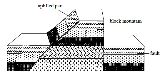
A block mountain refers to a table-like mountain formed due to the influence of faulting that leads to rising of crustal rocks. It is nearly a flat surface. A block mountain can be formed by either tensional or compressional forces. This is when the earth’s movements cause parallel faults which results into uplifting of some parts.
Examples of block mountains are:
- Usambara and Uluguru, in Tanzania;
- Ruwenzori, in Uganda;
- Vosges and Black Forest, in Europe; and
- Mount Sinai in Asia.
Plateau
A plateau is a large, extensive uplifted part of the earth’s crust which is almost flat at the top. The top of the plateau is mostly a plain. Plateaus were formed during Mesozoic and Jurassic eras. It was due to uplifting of the earth’s crust. Such landforms include those of East African and Brazilian plateaus. High plateaus especially in tropical latitudes are used for agriculture and settlement.

Basin
A basin is a large, extensive depression on the earth‘s surface. Most basins are formed due to vertical movement of the earth. Some basins are filled with water (Figure 2.8).

Examples of basins include:
- an inland drainage e.g. Congo basin;
- Chad basin; and
- Amazon basin.
ii. Lateral or horizontal movements.
Lateral or horizontal earth movements are sideway movements of the earth‘s crust which cause the crustal rocks either to fold, fault or form joints. They are caused by forces operating along a horizontal plane within the earth‘s crust
When the forces move away from each other, they cause tension (strain) as they are pulled apart. These forces are, therefore, referred to as tensional forces and cause the crust to stretch. If the forces move towards each other, they cause the crustal rocks to be compressed (squeezed) These forces are, therefore, called compressional forces. They cause the rocks to shorten, fold or even crack.
Horizontal movements also cause the shearing or tearing of the crustal rocks. This occurs when tectonic forces move in the opposite direction past each other.
Features resulting from the lateral or horizontal earth movements
Features produced due to this movement are folds, faults, joints, Fold Mountains, rift valleys, block mountains, etc.
Folds
A fold is a feature formed as a result of the wrinkling of the earth‘s crust due to compressional forces
Forms of folds
Symmetrical fold (simple fold), This is a fold which has equal slopes on both limbs as shown in Figure 2.9

Asymmetrical fold, This is a fold which has a steep slope on one limb and a gentle slope on another limb as shown in Figure 2.10.

Overthrust fold, This occurs when an anticline overliesa syncline
Overfold, This type of fold is formed where the compressional forces push one limb in asymmetrical fold over the other limb at a short distance (Figure 2.11)

Recumbent fold , This is formed when an overfold is pushed further by compressional forces towards another limb at a great distance (Figure 2.12)

Folding leads to the formation of Fold Mountains. Examples of Fold Mountains are Andes in South America, Rockies in America (North America), Himalayas in Asia, Atlas in Africa, Cape ranges in South Africa, Alps in Europe and Appalachian mountains in U.S.A. (North America)
Faulting
Faulting involves the fracturing of the earth‘s crust due to the movement of the rock blocks. These are cracks that occur across several layers of the earth‘s crust and are accompanied by displacement of blocks. The direct effects of faulting include the formation of landforms like the rift valley, block mountains, fault scarps, tilt block landscape, changes in the drainage system, and occurrence of earthquakes.
Forms of faults
Normal fault , This is a type of a fault that results from tensional forces as indicated in Figure 2.13.

Reverse fault, This is a type of fault caused by compressional forces (Figure 2.14).

Tear fault , As shown in figure 2.15, tear fold is a fault formed by vertical fractures where two blocks slide against each other

Joints
Joints are small cracks caused by internal stress set up by bending or folding. Joints occur in a single layer of rock and usually, they are not accompanied by displacement (Figure 2.16). Many joints develop on igneous rocks due to expansion and contraction. Important features resulting from joints are tors.

Vulcanicity
Difference between Vulcanicity and Volcanicity
Differentiate vulcanicity from volcanicity
This term refers to volcanic activities by which molten rock (magma) and gases are forced into the earth‘s crust and surface. Vulcanicity, therefore, includes volcanic eruptions, which lead to the formation of volcanoes and lava plateaus and geysers, and the formation of volcanic features such as batholiths, sills and dykes, etc, in the earth‘s crust.
Vulcanicity is when solid, liquid or gaseous materials are forced into the crust or on the earth‘s surface while volcanicity is the process through which igneous materials reach the earth‘s surface.
Causes of Volcanicity and Resulting Features
Explain causes of volcanicity and resulting features
There are two types of vulcanicity namely, intrusive vulcanicity and extrusive vulcanicity.
Intrusive (internal) vulcanicity
This occurs when the magma cools, solidifies and forms features within the earth‘s crust before it reaches the earth‘s surface. The features (landforms) formed by this process are sometimes termed as intrusive (internal) features.
The following are the landforms formed through intrusive vulcanicity:
Dyke
This is a wall-like feature cutting across the bedding planes. It is formed when magma cools and solidifies vertically across bedding planes. The dyke is termed as a small-scale intrusive feature. Sometimes the dyke may form a waterfall when exposed to the earth‘s surface due to denudation processes.
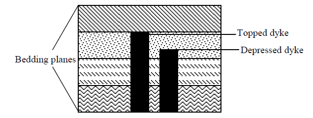
Examples of dykes are Mwadui dyke in Tanzania, Gabbro dyke in Lesotho, and Tyolo dyke in Malawi.
Sill
This is an intrusive feature which lies horizontally along the bedding planes. It is formed when magma cools and solidifies horizontally along a bedding plane. Like the dyke, the sill is termed as a small-scale intrusive feature.
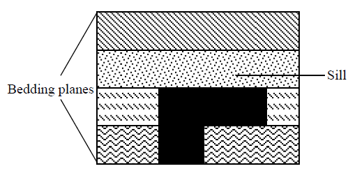
An example of a sill is Fouta Djallon ranges in Guinea.
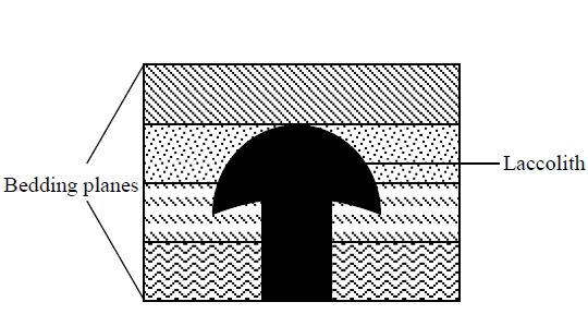
Laccolith
This is an intrusive feature which looks like a dome. It is formed when the magma cools and solidifies in anticline bedding plane. Sometimes it can be exposed to the earth‘s surface following denudation processes.
Lapolith
This is an intrusive feature which looks like a saucer in shape. It is formed when magma (molten rocks) cools and solidifies in a syncline bedding plane.
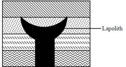
Examples of lapoliths are found in South Africa especially in Trans Vaal province.
Batholith
This is a very large mass of magma which cools and solidifies in the earth‘s crust. Sometimes if forms the root or core of a mountain. Batholiths are made of granite and they form surface features only after they have been exposed to the earth‘s surface by denudation. Sometimes batholiths resist erosion and form uplands.
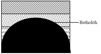
Examples of batholiths are found in Zimbabwe, Tanzania, Zambia and Gabon (The Chaillu Massif).
Phacolith
This is a lens-shaped mass of igneous rock. It is formed when magma cools and solidifies at anticline and syncline in folded rocks.
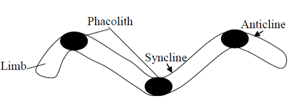
An example of a phacolith is The Gordon Hill in UK.
Features Resulting from the Processes of Volcanicity
Classify features resulting from the processes of volcanicity
Eruption of magma, either intrusive or extrusive, results in the formation of features. Intrusive features are the result of cooling and solidification of magma inside the crust. The features formed includes dyke, sill, laccolith and batholith. Extrusive features include the formation of volcanoes, domes, craters and calderas.
Distribution of Major Volcanic Zones in the World
Locate the distribution of major volcanic zones in the world
Extrusive (external) vulcanicity
This is the type of vulcanicity that occurs when molten rocks reach the surface of the earth. When magma emerges at the surface it is called lava. This forms features called extrusive features of vulcanicity. The following are landforms due to extrusive vulcanicity:
Acidic lava cone
This is a cone made of viscous lava. Normally lava cones have high heights and break into small fragments. The acidic lava always cools faster than basic lava because is it viscous.
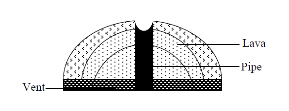
Examples of acidic lava cone include:Mount Kilimanjaro found in Tanzania (East Africa).Mount Kenya found in Kenya (East Africa).Mount Fuji found in Japan.Mount Vesuvius found in Italy.
Basic lava cone
This is a cone made up of basic (fluid) lava. Normally cones have gentle slopes and spread over a long distance.
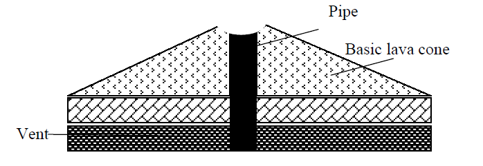
Examples of basic lava cones are Mauna Loa cone of Hawaii and basaltic dome of Nyamlangir, near to Lake Kivu in DRC.
Ash and cinder cone
This is a cone made up of ashes and stones that erupted from beneath (interior) the earth to form a concave cone. The slopes of a cone are usually concave due to the spreading tendency. Lava is blown to great heights when it is violently ejected, and it breaks into small fragments which fall back to the earth and build up a cone.
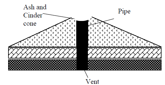
Several ash and cinder cones occur just south of Turkana, in Kenya. These are Likaiyu and Teleki (both cinder cones), and Nabuyatom (ash cone).Other examples of cinder cones outside Africa are Volcano de Fuego, in Guatemala and Paricutin, in Mexico.
Crater
The crater is a small depression on the volcanic cone or mountain. It is sometimes filled with water to form a crater lake. It is formed when volcanic eruption ceases and leaves a hole on the basic lava cone. An example of a crater is Ngorongoro crater in Tanzania.

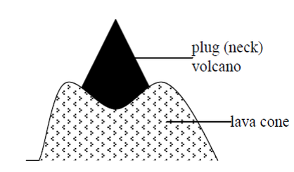
Volcanic plug
This is a big rock which plugs or blocks the top of the pipe. It is formed when lava solidifies quickly to block the pipe. Examples of volcanic plugs are Mount Palace in France and Hoggar mountains in Algeria.
Composite cone
This type of a cone is formed of alternate layers of ash and lava. The volcano begins each eruption with great violence forming a layer of ash. As the eruption proceeds, the violence ceases and lava pours out forming a layer on top of the ash.
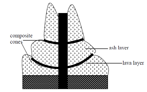
Examples of composite cones are Mount Kilimanjaro, in Tanzania and Mount Cameroon. Other examples outside Africa are Vesuvius, Etna and Stromboli, all of which are in Italy.
Caldera
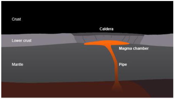
This is a large depression on top of a volcanic cone. It is formed when a composite volcano explodes so violently that its top is blown off and disintegrates into a mass of rocks and ashes, leaving the crater greatly enlarged. This huge crater-like depression is what we call a caldera. Sometimes a caldera can be filed with water to form a caldera lake. Lake Shala, in Ethiopia, is the largest caldera lake in the world.
Examples of calderas are:
- Ebogar caldera, in Cameroon
- Longonot caldera, in Kenya, which lies in the Eastern Rift Valley, about 140 km south of Mount Kenya.
The stages in the formation of a caldera
First stage:Magma cannot escape to the surface and collects under the lower crust.
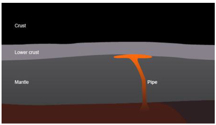
Second stage:An 'uplifted bulge' begins to form under the lower crust as the magma chamber enlarges.
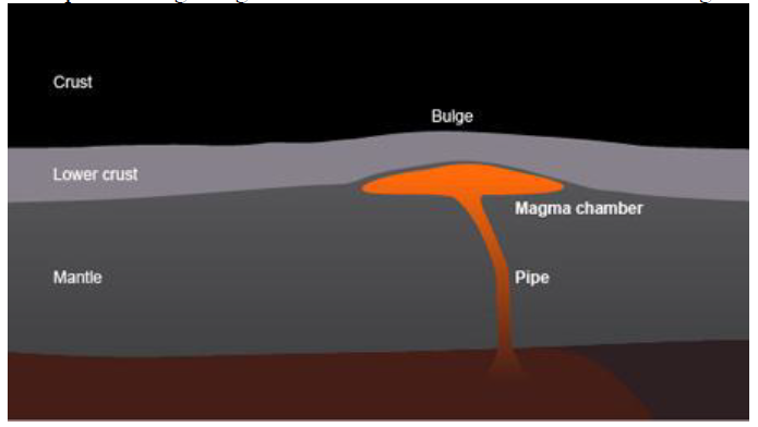
Third stage:Cracks appear on the surface. Gas and ash erupt from the magma chamber through these cracks.
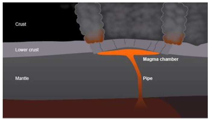
Fourth stage:The magma chamber collapses and a depression is formed. This is called a caldera.
Geysers and hot springs
- A geyser refers to the forceful emission of hot water and steam from the ground to a high level in the air. The ejected water contains fine materials such as volcano mud, which later form fertile soils. Geysers are found in Iceland, North Island and New Zealand.
- A hot spring refers to natural outflow of superheated water from the ground. It contains mineral substances in solution. Hot springs are found in Iceland, in Europe; and Kenya and Ethiopia, in Africa.

Hot springs are also found in Manyara National Park, Songwe, in Mbeya and in Nigeria.
Lava plateau
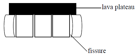
This is an extensive and flat landform which is formed when molten magma flows onto the earth‘s crust through fissure. Examples are found in Ethiopia highland, Bui plateau in Nigeria and Daccan plateau in India.
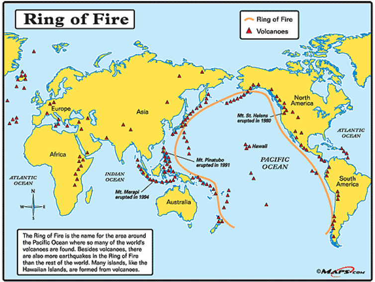
Distribution of major volcanic zones in the world
The distribution of volcanoes is as shown in the world map below. Most volcanoes are found in continents bordering the Pacific Ocean, an area referred to as Ring of Fire. The Ring of Fire is the name for the area around the Pacific Ocean where so many of the world‘s volcanoes are found. Besides volcanoes, there are also more earthquakes in Ring of Fire than the rest of the world. Many islands, like the Hawaiian Islands, are formed from volcanoes.
The Economic Importance of Volcanoes
Assess the economic importance of volcanoes
Vulcanicity results to features that are of economic value to man as outlined below:
- The larva poured onto the earth‘s surface following vulcanicity forms a fertile soil upon weathering. This soil supports agriculture as well as forestry. Examples of fertile volcanic soils that resulted from volcanic activities are the rich acidic soils on the slopes of mounts Kilimanjaro, Kenya and Elgon, which supports the growth of coffee, banana, tea and other crops.
- When the magma solidifies, it forms hard rocks that can be quarried and used to construct roads, bridges, houses and other infrastructures.
- Spectacular features formed upon vulcanicity such as mountains, calderas, caldera lakes, cones, geysers and hot springs are interesting to look at. As such, they attract tourist and hence earn foreign currency to the country.
- Vulcanicity brings minerals from deep the earth‘s crust to close or onto the earth‘s surface. Various minerals and gemstones are mainly found in the volcanic regions. Diamond in Mwadui is mined from the volcanic plugs and dykes. Gold and silver are associated with the Nyanza batholith in Kenya.
- Geysers can be harnessed to generate geothermal electricity. Geothermal power is tapped from geysers in volcanic regions. In East Africa, geothermal power stations are established at Olkaria near Naivasha in Kenya.
- Hot water from hot springs is pumped into homes during winter to heat up homes. This is done in cold countries like Iceland and New Zealand.
- People use hot springs and pools of hot water as spas. They bathe in the water for the purpose of curing certain diseases.
- Some crater lakes are a source of salts and other minerals while others support fishing activities, for example Lake Chala. Some lakes are a source of fresh water for domestic and industrial uses.
Earth-quakes
Earthquake, Epicenter and Focus
Define earthquake, epicenter and focus
Earthquakes refer to the sudden shaking or vibrations of the earth’s crust due to sudden and rapid displacement of tectonic plates along the line of weakness (faults). It occurs mainly in volcanic eruption zones (see a map of volcanic zones above). The point from which the earthquake originates is known as focus and the intensity of earthquakes can be measured by using an instrument called seismograph. The point on the surface vertically above the focus is called epicentre
How Earthquake can be Detected
Describe how earthquake can be detected
The intensity and magnitude measure the strength of the earthquake. These are obtained by detecting the Seismic waves using instruments called seismograph or seismometer.
Intensity is a measure of how hard the earthquake shakes the ground. It is determined through the effects produced by the earthquake. Intensity varies from one place to another. While the intensity of a specific earthquake varies, its magnitude does not vary. So it is important not to confuse magnitude with intensity.
The scale which measures the intensity is called Mercalli scale. It ranges from undetectable, moderate, strong to major catastrophe. Magnitude refers to the total amount of energy released and it is given on the Ritcher scale. This scale ranges from 0 to 8.9.
The Causes and Effects of Earthquake
Explain the causes and effects of earthquake
Causes of earthquakes
- Faulting of the lithosphere caused by tectonic movement where one plate slides over another plate.
- Vulcanism can cause occurrence of the earthquake. This is due to the fact that the magma moves under the influence of intense pressure from within the earth’s interior.
- Mass wasting like land slide and rock fall can cause occurrence of earthquake, but this is for local scale.
- Falling objects from the atmosphere such as meteorites may lead to the shaking earth’s crust.
- Man’s influence through his activities such as mining using explosives like dynamites and transport vessels like trains and heavy trucks.
Effects of earthquakes
- They can cause loss of life and property. An earthquake is a natural disaster. Whenever it occurs, it causes a lot of disturbances including loss of life and properties. For example, the earthquake that hit Toro in Uganda in 1966 killed 157 people, injured about 1300 people and destroyed about 6000 houses. The earthquake which occurred in California–Mexico border in 1975 caused damage running into millions of dollars and injured 100 people on both sides of the border where most of them suffered cuts from flying glass and debris. And the earthquake that occurred in Northridge in the San Fernando Valley in California in January 1994 killed 61 people and caused damage estimated at ten to thirty billion dollars. This damage includes the cost of structures that collapsed such as California Highway, when the earthquake turned the flyover to ruins.
- They can displace parts of the earth’s crust vertically or laterally.
- They can raise or lower parts of the sea floor. The Agadir earthquake in Morocco in 1960 raised the sea flour off the coast. In some areas the depth of the sea decreased from 400 m to 15 m after the earthquake.
- They can raise or lower coastal rocks. In the Alaskan earthquake of 1899, some coastal rocks were raised by 16 m.
- They can cause landslide and open up deep cracks in the surface rocks. The El Asnam earthquake in Algeria, in 1954, destroyed an area of radius 40 km and opened up deep cracks up to 3 m deep.
The possible Areas where Earthquake is likely to Occur on the World Map
Locate the possible areas where earthquake is likely to occur on the world map
Precautionary measures to avoid high damage from earthquakes
- Refraining from building high-rising structures on the land vulnerable to earthquake as well as strengthening buildings by using reinforced concrete, steel frames, deep foundations and light roofs.
- Geologists should detect epicentres and tell the people to evacuate the places likely to be affected by earthquakes.
- To avoid constructing very large water bodies like Kariba dam which can cause the earthquakes due to the weight of water and other materials.
- Discouraging the use of explosives like dynamites in breaking the rocks during mining and construction operations.
External Forces
These are natural forces that operate on the earth’s surface. The forces mainly act on the earth’s crust or close the surface of the earth. Often the features produced by these forces are seen on the surface of the earth. They include mountains, volcanoes, moraines and valleys, just to mention a few.
Mass Wasting
Define mass wasting
Mass wasting also known as slope movement or mass movement, is the movement of the weathered materials downslope due to gravitational forces accompanied by rain action.
Types of Mass Wasting
Identify types of mass wasting
Types of mass movement are distinguished based on how the soil, regolith or rock moves down the slope as a whole. Based on this factor, mass wasting can be categorized or grouped into two types. These are slow and rapid mass movements, each with its own characteristic features, and taking place over timescales from seconds to years.
Slow mass movement
This is the movement of soil at very slow speed, water acting as the lubricant. Slow mass wasting is categorized into several types. These are as follows.
Soil creep
Soil creep is the slow movement of the soil downhill after it gets soaked by water. This process is very slow and its evidence is provided by tilting of trees and falling of buildings and fences.
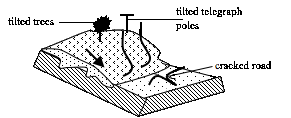
Soil creep is activated by any process that loosens the soil, making it easy to move gradually down the slope. The following factors influence soil creep:
- Alternate heating and cooling of the soil particles.
- The freezing of water in the soil causing frost heaving.
- Removal of the soil further down the slope.
- Percolation of water into the soil, acting as a lubricant.
- Ploughing of the soil, a fact which makes the soil loose and more mobile.
Talus Creep
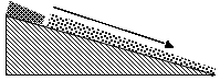
This is also a very slow mass movement of screes. It is very common on sides of mountains, scarps and valleys. It takes place due to the processes of thawing and freezing and is more pronounced in high latitude regions.
Rock creep
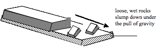
Individual rock blocks may move very slowly down a slope. It occurs commonly where individual rock blocks are lying over clay materials. In the presence of moisture, the clay surface becomes slightly slippery. The rock blocks may creep slowly down the slope under the influence of gravity.
Solifluction
This is the slow movement or flowing of weathered materials, especially when mixed with water and gravels. It is limited on highlands and cold regions.
Rapid mass wasting
This involves the movement of materials in form of mudflow,land slide, rock fall and earth flow.
Earth flow
This type of movement occurs in humid regions. The materials on the earth’s surface gets so saturated with water that it gains much weight, and starts to move down the slope under the influence of gravity.This normally occurs on the slopes of the hills or mountains. The removed earth material leaves a shallow scar on its place of origin and it creates terraces or mounds in its destination.
Mud flow
Mud flow is the movement of a large mass of unconsolidated rocks down the slope when saturated with water. It flows in semi liquid state. It is common in desert slopes, which are not protected by a cover of vegetation. This occurs, for instance, during a torrential storm when more rain falls than the soil can absorb.
Land slide
This is the rapid movement of surface rocks and soil down a steep slope such as a cliff face. It includes slumping and sliding of materials. During the movement, the block tilts and leaves holes. It is common in well jointed limestone rocks, shale or clays. The common forms of landslides are slump, debris slide,rock slide, rock fall, debris fall and avalanche.
Rock fall
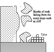
This is the free-falling of a single mass of rock, common on steep slopes of mountains and along scarp slopes of the sea. This is the most rapid of all mass movements. If a rock fall occurs repeatedly, for a long time, the broken rocks collect at the bottom of the slope in a mound called talus.
The Factors which Cause Mass Wasting
Describe the factors which cause mass wasting
Mass wasting is caused by a number of factors which include the following:
- Gradient or slope:When the gravitational force acting on a slope exceeds its resisting force, slope failure (mass wasting) occurs. Mass wasting is very common and severe in areas with steep lands as compared to flat or moderately flat lands.
- Weathering:Various processes of weathering weaken and loosen the rock, hence accelerating the process of mass wasting. For example, oxidation of metallic elements and hydration of the minerals in rocks create lines of fracture and, consequently, the onset of mass wasting.
- Amount of water present in the rocks:Water can increase or decrease the stability of a slope depending on the amount present. Small amounts of water can strengthen soils because the surface tension of water increases soil cohesion. This allows the soil to resist erosion better than if it were dry. If too much water is present the water acts as lubricating agent, reducing friction, and accelerating the erosion process, resulting in different types of mass wasting (i.e. mudflows, landslides, etc.). Water also increases the mass of the soil, this is important because an increase in mass means that there will be an increase in velocity and mass wasting is triggered. This is due to the fact that water lowers resistance of the soil material to gravitational forces and this facilitates movement.
- Vegetation:The roots of plants help bind the soil particles together making the soil resistant to agents of erosion and weathering. A compact soil cannot be eroded easily by running water, animals, wind or other agents of erosion. This makes the soil hard to break and hence resistant erode. Mass wasting processes, such as soil creep, cannot occur easily in soils well-covered with vegetation. Also the mass of vegetation cover blocks and prevents movement of the eroded material.Plants remove water from the ground via absorption. This reduces the amount of water in the soil and hence the bulkiness and weight of the soil. By so doing, they reduce the quantity of water in the soil. And because water lubricates the soil particles, enabling them to move, reducing this water means minimizing mass wasting.The sliding of bedding planes over each other is also reduced.
- The nature or type of the rock materials:Clay soil is compact and resistant to various types of soil erosion agents and mass wasting as compared to sandy soil, which is normally loose and easy to remove and transport by water, gravity, wind, etc. Thus, mass wasting may be more severe on sandy soil than its counterpart clay soil under similar prevailing conditions.
- Overloading:When the soil accumulates in one location as a heavy mass of the rock material, it can be moved either by action of gravitational force or application of just a little force. Landslides occur as a result of the soil accumulated on a sloping land to an extent of exceeding the resistant force of gravity. Movement occurs when the gravitational force exceeds the resistant force of soil material.
- Earthquakes:Earthquakes cause sections of the mountains and hills to break off and slide down. Earthquake tremors tend to loosen the soil material and make it easy to be removed and transported. It can accelerate rock falls, landslides and soil creeps.
- Human activities:The activities of man such as cultivation, burning, mining, transportation, animal grazing, etc, removes the soil cover or leads to shaking of the soil. These activities leads to loosening of the soil particles and hence making it ease to remove and carry away. Quarrying by undercutting the slope creates a vacuum underneath the soil. This accelerates the earth movement in the form of landslide, soil creep and mud flow, especially when accompanied by tremors cause by earthquake or heavy vehicles passing nearby.
- Climate:Climate has a great influence on mass wasting. Areas that receive heavy rains often experience mass movements, such as landslides and soil creep, more often compared to dry areas. On the other hand, a little amount of rainfall does not wet the soil and so cannot cause the soil to move.In cold regions, alternate freezing and thawing triggers mass wasting. When the water in the soil freezes it expands. This causes the soil to be lifted up. In the due course, the rock particles are split apart of broken down. This entire process causes movement of the soil material down the slope.
- Vulcanicity:Volcanic activity often causes huge mud flows when the icy cover of a volcano melts and mixes with the soil to form mud as the magma in the volcano stirs preceding an eruption.
The Effects of Mass Wasting to the Environment
Assess the effects of mass wasting to the environment
Mass wasting has significant effects to the environment. The following are some of the effects of mass wasting to the environment:
- Formation of scars and bare land:When a large mass of soil moves, such as it occurs in landslide, the process leaves behind a large portion of eroded, bare and unproductive land. This land is often not easily colonized by plants, a fact which stimulates further erosion on the bare scar. Scars are very common on slopes of mountains such as mounts Kilimanjaro, Kenya and Rwenzori.
- Soil erosion:When mass movement takes place, the load often removes almost all the vegetation on its way. This exposes the land to agents of erosion such as wind, animals, water, ice, waves, etc. Also the place from which the material has been removed forms a scar upon which water, ice and other agents of erosion can act and remove the soil, further leading to gullies, depressions and gorges.
- Formation of new landforms:The materials removed and transported to a distant location may form hills at their destination and form scars and depressions at the place of origin.
- Formation of lakes:Materials of landslide can block a river bed and valley, preventing downward movement of water. The blocked water accumulates on the upper side of a river valley to form a lake. Examples of such lakes include Lake Bujuku in the Rwenzori Mountains,Nyabihoho in Uganda and Funduzi in South Africa. Lake San Cristobal in Colorado, USA, was formed when mud flow dammed (blocked) a river in the San Juan Mountains.
- Diversion of a river course:The landslide material can block the natural river bed, forcing the river to divert and form a new route. This makes the river leave its usual flowing course, and form a new course. The direction of flow of the river is thus changed. This happened in the Rif Atlas Mountains of Morocco in 1963 when a mud flow pushed the course of River Rhesana 100 metres to the east.
- Formation of a fertile soil:If the removed material comes from a fertile land, it can form a fertile soil at the place of destination, where fertile soil never existed, and encourage agricultural activities to take place.
- Damage to property:Different categories of landslides may cause various damages to property and can adversely affect other resources. The effects of landslide are dangerous because they destroy everything in their path. Roads are blocked, hampering traffic flow. Homes, buildings and other infrastructures are destroyed. The water mains, sewers and power transmission lines are disrupted. Oil and gas production and transportation facilities are ruined.Farms are also destroyed by various forms of mass wasting.
- Loss of life:As human populations expand and occupy more and more of the land surface, mass movement processes become more likely to affect humans. The table below shows the impact of mass movement processes on human life over the last century.
| Year | Location | Type | Fatalities |
| 1916 | Italy, Austria | Landslide | 10,000 |
| 1920 | China | Earthquake triggered landslide | 200,000 |
| 1945 | Japan | Flood triggered landslide | 1,200 |
| 1949 | USSR | Earthquake triggered landslide | 12,000-20,000 |
| 1954 | Austria | Landslide | 200 |
| 1962 | Peru | Landslide | 4,000-5,000 |
| 1963 | Italy | Landslide | 2,000 |
| 1970 | Peru | Earthquake related debris avalanche | 70,000 |
| 1985 | Columbia | Mudflow related to volcanic eruption | 23,000 |
| 1987 | Ecuador | Earthquake related landslide | 1,000 |
| 1998 | Nicaragua | Debris avalanche and mudflow triggered by heavy rains during Hurricane Mitch | ~2,000 |
| 2001 | El Salvador | Earthquake-induced landslide | 585 |
| 2006 | Philippines | Rain triggered debris avalanche | >1100 |
| 2009 | Taiwan | Typhoon Marakottriggered landslide | 397 |
| 2010 | Gansu, China | Rain triggered mudflows | 1287 |
| 2013 | Northern India | Heavy rain triggered landslides | 5700 |

Weathering
Weathering
Define the term weathering
Weathering refers to a processes where by rocks disintegrate into small particles due to the agents of weathering such as water, ice, wind, wave, etc. The process results from the forces of weather, that is, changes in temperature, frost action and rain action.
Types of Weathering
Identify types of weathering
The main forms of weathering include:
- Mechanical weathering
- Chemical weathering
- Biological weathering.
Mechanical weathering
This is also referred to as physical weathering. It is a type of weathering caused by changes in temperature. It is common in areas where there are extreme changes in temperature such as hot deserts, arid and semi arid regions.
Mechanical weathering include the following types:
Exfoliation
This process occurs due to temperature change. During the day time rocks expand due to high temperatures and contract during the night due to low temperatures.Alternate heating and cooling set up powerful internal stress in the top layer of the rocks.The stress produces fractures which cause the outer layer to pull away leading to the cracking and disintegration of rocks into small particles.
The peeled off rock fragments fall to the bottom of the standing rocks and are subjected to further alternate expansion and contraction and disintegrate to even smaller fragments. The fragments collect at the base of the standing rocks to form mounds of steeply sloping rock fragments called talus or sometimes screes, but the term is better used for angular rock particles produced by the action of frost. The rocks that remain standing as exfoliation takes place are called exfoliation domes. Exfoliation domes occur in desert, semi-desert and monsoon regions. There are many exfoliation domes in the Egyptian, Kalahari, Sahara and Sinai deserts.
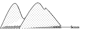
Frost action
This is common in temperate regions where temperature falls up to freezing point. When temperature falls (freezing point) water collects in the rocks and it freezes, its volume increases causing the crack to deepen and widen. Usually it involves the freezing of water in the cracks during the night and thawing (melting) during the day in mountainous areas.This action of thawing (melting) and freezing of water in the cracks cause the rocks to shatter (break) into angular fragments which form screes and talus. After thawing the cracks deepen further.
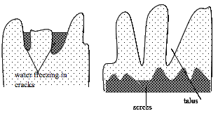
Alternate wetting and drying
This usually occurs in tropical regions. These areas have seasonal rainfall and they get rain during summer season and during winter season they are dry. This causes the blocks to disintegrate.

Differences between Weathering Processes
Differentiate weathering processes
Chemical weathering
Chemical weathering involves the decomposition of some of the minerals contained in a rock. Some rocks decompose when they come into contact with water (H2O), or oxygen (O2) and carbon dioxide (CO2), two of the gases that make up air.Chemical weathering includes the following processes:
- Oxidation– This happens when oxygen combines with a mineral. It takes place actively in rocks containing iron, when oxygen combines with iron to form iron oxides. This process is often preceded and accompanied by hydrolysis.The new minerals formed by oxidation are often easily attacked by other weathering processes.
- Carbonation– This process occurs when hydrogencarbonate ions react with a mineral to give a solublecompound whichcan be carried away in solution. Hydrolysis often accompanies carbonation.
- Solution–This refers to dissolution of a mineral with a chemical substance.Rain watercombines with both atmospheric carbon dioxide and oxygen to form weak carbonic acid. CO2(g) + H2O(l) → H2CO3(aq).So when the rain reaches the ground it consists of a weak acid called weak carbonic acid. This acid helps to dissolve many insoluble minerals into minerals soluble in water, and which can be carried away in solution. When rain containing weak carbonic acid falls in a limestone region, it reacts with limestone (calcium carbonate) and dissolves it into soluble calcium hydrogen carbonate, which can easily be carried away in solution.CaCO3(s) +H2CO3(aq) → Ca(HCO3)2(aq)In limestone regions, the rocks are dissolved and produce features like grike andclint(trough and ridge).
- Hydration– This is the process in which some minerals absorb water and swell up, causing internal stress and fracture of the rocks.
- Hydrolysis– This process involves the reaction of hydrogen (in the water) with certain mineral ions (in a mineral). This gives rise to the formation of different chemical compounds that can be easily weathered through other weathering processes.
NOTE: Usually two or more chemical weathering processes take place at the same time. Chemical weathering is most marked in hot wet regions.
Biological weathering:When plants grow on rocks, their roots penetrate into rock joints which later force the rocks to break apart. Also man contributes much to rock disintegration through farming activities, mining, quarrying and construction. Macro- and microorganisms also disintegrate rocks through burrowing and by mineralization process. Bacteria, for example, in the presence of air, break some minerals which are dissolved in the soil. Plants also absorb minerals from the soil by their roots. Decayed vegetation produce organic acid which remain in the soil. All of these actions help to weaken the rocks.
The Significance of Weathering
Assess the significance of weathering
Weathering is important to man in the following ways:
- Weathering leads to soil formation. Soil is formed through the process of weathering of rocks. Various forms of weathering lead to rock disintegration and hence formation of the soil. The soil is an aggregate of organic and inorganic particles formed by different processes of weathering.
- Weathering may shape the rocks into attractive features which can attract tourists and hence earn the country and communities the much needed foreign exchange. An example of a feature that can attract tourists is the Bismarck Rock on the south shore of Lake Victoria.
- The processes of weathering weaken the rocks such that they can be easily acted upon by agents of erosion. The process helps to shape the earth and produce various landforms. This, in turn, influences the type of human activities that can take place in an area. So the process is very important in supporting life.
- When the rocks are weathered they become weak and hence easy to exploit, e.g. by quarrying. This process also helps to break up large rocks into small fragments such as sand, which is used for construction purposes.
- Weathering serves as carbon sink.Any process that reduces the amount of carbon dioxide from the atmosphere is termed as carbon sink. Some processes of weathering involve absorption of carbon dioxide from the atmosphere. This helps to remove excess carbon dioxide from the atmosphere. Limestone and other carbon-based sedimentary rocks are important carbon sinks.
Erosion and Deposition by Running Water, Ice, Wind and Wave Action
The Concept of Erosion and Deposition
Define the concept of erosion and deposition
River refers to a mass of water flowing through a definite channel over a landscape from river source to river mouth. River source is the place where a river starts. It may be in the melt water from glacier e.g. river Rhome (France), a lake, e.g. Lake Victoria, the source of river Nile, a spring e.g. Thames (England) or it can be formed following steady rainfall e.g. river Congo. River mouth can be anywhere a river pours its water, e.g. a lake, ocean or sea.
How Agents of Erosion and Deposition Operate on the Landscape
Examine how agents of erosion and deposition operate on the landscape
Erosionis the removal of surface material from earth‘s crust, primarily soil and rock debris, and the transportation of the eroded materials by natural agents (such as water or wind) from the point of removal to a new location
Deposition is the process by which sediment settles out of the water or wind that is carrying it and is deposited in a new location
Features formed by rain action
Rain action produces several types of features of which the most common are gullies and earth pillars.
1.Gully, This is a deep groove formed by the action of running water on a gently sloping land that has little or no vegetation. Gullies are sometimes referred to as badlands. They develop largely in semi-arid areas.
2. Earth pillar, This is the up-standing ridge capped with boulders. It is formed when rain falls on the mountain slopes consisting of boulders and clay is removed rapidly except where boulders protect it. Formation of the earth pillar is shown by figures 2.45 and 2.46.


River System and Associated Features
River refers to a mass of water flowing through a definite channel over a landscape from the source to the mouth of the river. River source is the place where a river starts. The source can be in the form of water meltingfromthe glacier e.g. river Rhome (France);a lake, e.g. Lake Victoria (the source of river Nile); a spring e.g. Thames (England); or it can be formed following steady rainfall e.g. river Congo. River mouth can be anywhere a river pours its water, e.g. a lake, ocean or sea.
River erosion, transport and deposition
The river has three functions as it flows through its channel. These are river erosion, transportation and deposition.
River erosion
Erosion of a river operates in three ways, that is, head ward, vertical and lateral erosions.
- Headward erosion– this is the cutting back of the river at its source. It is through this erosion that a river increases its length.
- Vertical erosion– this is erosion by which a river deepens its channel.
- Lateral erosion– This is the wearing away of the sides of a river by water and its load. It is responsible for widening of a river valley.
River erosion involves four related processes. These are abrasion (corrasion), attrition, corrosion (solution) and hydraulic action.
- Hydraulic action:This is the process whereby the force of moving water plucks and sweeps away loose materials, such as silt, gravel and pebbles. Materials plucked by hydraulic action are responsible for bank caving and slumping.
- Corrasion (abrasion):This is when the load of the river rubs against the bed and sides of the river channel. This causes wearing away of the sides and bed of the river. The amount of load determines the nature of erosive power and rate of erosion. This is a source of pot holes in the river bed.
- Attrition:This is when the rock fragments in a river’s load are broken into small fragments due to collision against one another as the load is carried downstream along the river channel. As the river moves along its course, its fragments get progressively smaller because of disintegration and wearing away.
- Corrosion (solution):River water dissolves certain minerals leading to dissolution and disappearance of some rocks, e.g. limestone, rock salt and chalk.
River transport
This is the process which involves carrying away of the weathered and eroded, loose materials from one place to another. The materials carried out by river is called load. River transports its load in four ways. These ways are as follows:
- Saltation– this is the process in which small pieces of the rock fragments are carried by a river while bouncing on the river bed.
- Traction– this is the dragging or rolling of large boulder such as pebbles along itsriver bed.
- Suspension– This involves transport of fine or light materials like silt and mud, which are carried in suspension forms. This is common when the river flow is too strong.
- Solution– this involves moving some materials that dissolve in water, which are carried away in solution form.
A river transports its load until it has insufficient energy to transport it any further. When this happens, the load is deposited.
River deposition
A river deposits its load when its volume and speed decrease. A river volume decreases when:
- It enters an arid region especially a hot desert;
- It crosses a region composed of a porous rocks e.g. sand and limestone; and
- During the dry seasons or in a period of drought.
A river speed decreases when:
- It enters a lake or sea; or
- When it enters flat or gently slopping plain such as a valley bottom.
Deposition takes place when the river has insufficient energy to carry its entire load. The first part of the load that is dropped consists of boulders and pebbles. The last part to be dropped is the fine sediment, called silt. Deposition takes place at any point in a river’s course.
THE LONG PROFILE OF A RIVER
The long profile of a river is the line following the course of a river from its source to its mouth. Three courses or sections of a river can be distinguished. These are:
- The upper course.
- The middle course.
- The lower course.
The upper course/section
This is the first stage of a river. It is sometimes called the youth or torrent course.Its characteristics are as follows:
- It is the river source.
- The speed of a river is high.
- Most of the works of the river include vertical erosion.
- The cross-section of a river valley in this section of a river is V–shaped.
- The slope of a profile is very steep.
- It is sometimes utilized for hydroelectric power (H.E.P) generation.
Erosional and Depositional Features for each Agent
Examine erosional and Depositional Features for each Agent
The main features of the upper section are deep and narrow, V-shaped valley; a steep gradient; pot holes on the river bed; interlocking spurs and waterfalls and rapids, often with plunge pools.
- V–shaped valley: this is a deep, narrow valley at youth/first stage of a river.
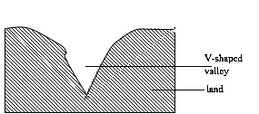
- Pot holes:These are circular depressions on the river bed. They are formed when pebbles carried by the swirling water cut circular depressions in the river’s bed.
- Interlocking spurs:An interlocking spur, also known as an overlapping spur, is one of any of a number of projecting ridges that extend alternately from the opposite sides of the wall of a young,V-shaped valley down which a river with a winding course flows. Each of these spurs extends laterally into a concave bend of the river such that when viewed either upstream or from overhead, the projecting ridges, which are called spurs, appear to "interlock" or "overlap" in a staggered formation like the teeth of a zipper.As the river erodes the landscape in the upper course, it winds and bends to avoid areas of hard rock. This creates interlocking spurs.
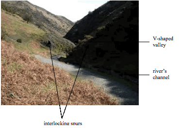
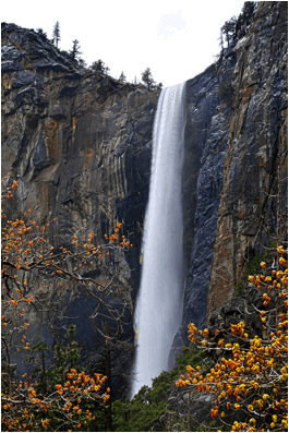
- Waterfalls and rapids-Waterfall:A waterfall is a place where water flows over a vertical drop in the course of a stream or river. A waterfall is formed when there is sudden change or drop in the bed of a river. Although waterfalls can occur in almost any part of a river’s course, they are most common in the upper course. Examples of waterfalls are Owen Falls in Uganda, Victoria Falls in Zimbabwe and The Livingstone
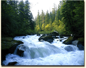
- Rapids:These are sections of a river where the river bed has a relatively steep gradient, causing an increase in water velocity and turbulence.Rapids are characterised by the river becoming shallower with some rocks exposed above the flow surface. As flowing water splashes over and around the rocks, air bubbles become mixed in with it and portions of the surface acquire a white colour, forming what is called "whitewater".Rapids occur where the bed material is highly resistant to the erosive power of the stream in comparison with the bed downstream. Very young streams flowing across solid rock may be rapids for much of their length.
- Plunge pool:This is a large depression formed at the base of a waterfall.

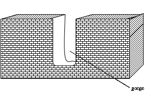
- Gorge:It is a steep, narrow and elongated valley. A gorge often is formed when a waterfall retreats upstream, e.g. a gorge found in Victoria Falls.
The middle/maturity stage/section
This is the second stage of a river. The main features of this section are bluffs and waterfalls and rapids.
The characteristics features of the middle course of a river valley
- The speed of a river is fairly low.
- Most of the work of a river is transportation.
- The cross–section of a valley in this section is an open V.
- The slope of a relief is gentle
- The volume of a river increases.
- Lateral erosion predominates.
Features associated with the middle course of a river valley
- Bluffs:These are steep slopes of the truncated spurs in middle course where interlocking spurs turn into bluffs.
- Waterfalls and rapids:Waterfalls and rapids can also be found in the middle stage of the river valley. This is mainly caused by river rejuvenation which increases erosive activity and transportation, hence development of waterfalls.
The old/lower stag
Third is the third stage of a river. The main features of the lower section of a river valley are a flood plain; braided river; ox-bow lake; levee and deferred tributary and delta.
Its characteristics are as follows:
- It is the river mouth.
- Always there are gradient falls or slope falls.
- The main work of a river is deposition.
- The cross–section of a valley is a U–shaped valley.
- The speed of a river is decreased.
- The river valley is very wide.
Characteristics features of the lower course of a river valley
1. Flood plain;This is a gently sloping plain of alluvium covering the valley floor down which the river flows in a meandering channel. The flood plain is normally formed when sediments deposited on the valley floor produces a gently sloping surface. This is what we call a flood plain. This often is marshy and contains numerous ox-bow lakes. Most of the features of the old stage are found in flood plain.
2. Braided river; This is a river that has split into several channels due to the deposition of materials on the valley floor. At some points along its channel, the river splits and rejoins again
A river with a heavy load becomes over-loaded in the dry season when the amount of water in the river falls and deposition takes place in the form of sandbanks and islands of alluvium that cause the channel to braid (see Figure 2.56).

i. River meander; This is the bending of a river (Figure 2.58). A meander forms when moving water in a river or stream erodes the outer banks and widens its valley and the inner part of the river has less energy and deposits silt. A stream of any volume may assume a meandering course, alternately eroding sediments from the outside of a bend and depositing them on the inside as shown in Figure 2.57.


ii. Ox-bow lake; This is a lake formed after the meanders have been cut off
Formation of an ox-bow lake
An ox-bow lake forms when the meander is so acute that only a narrow neck separates the two ends of the meander. Active lateral erosion takes place on the outside of the bends and the neck is eventually broken through. This often occurs when the river is in flood. The cut ends of the meander are sealed by deposition and the meander now becomes an ox-bow lake.
Active erosion takes place on the outside banks of a river channel and the eroded material is deposited on the neck of the meandering river. Figures 2.59 -2.61 show the stages of formation of an ox-bow lake.

The neck of land separates two concave banks where erosion is active.

The neck is ultimately cut through. This may be accelerated by flooding.

iii. Natural levees; When a river is in flood and flows over its banks, deposition takes place on the banks. Repeated flooding causes the banks to be raised and these are called levees (Figure 2.62). These occur along parts of the banks of River Benue.

iv. Deferred junctions; These tributaries lie parallel to the main river for long distances, sometimes several kilometres (see Figure 2.63). They could be joined again to the main river or not. This phenomenon occurs after the river bed is raised to necessitate the river to flow above the level of its bed. This makes it difficult for tributaries to join the main river. A tributary whose confluence is interfered with in this way is said to have its junction deferred (a deferred junction). It is sometimes called a deferred tributary
Examples of rivers with deferred junctions are the Mississippi river in USA, and Hwang-Ho and Yangtze-Kiang in China. All these rivers flow above their flood plains.

v. Deltas; This is the low-lying swampy plain at the mouth of a river which eventually becomes colonized by various types of plants. It is the result of prolonged deposition and collection of a load at the river‘s mouth. The growth of a delta interferes with the river's flow, causing the river to split into channels before entering the sea or lake. These channels are called distributaries
Conditions necessary for delta formation
- The river must have a large load. This will be possible if there is active erosion in the upper and middle stages
- There should not be extensive deposition in the middle stage, e.g., a lake in between or a high evaporation rate
- The river‘s load must be deposited faster than the action of currents and tides can remove it.
- Presence of shallow adjoining sea or continental shelf.
- The velocity of a river must be sufficiently low to allow most of its load to be deposited in the river‘s mouth
Four types of deltas
- Arcuate delta
- Digitate delta
- Estuarine delta
- Cuspate delta
i. Arcuate delta; This is the type of a delta composed mainly of sediments such as gravel and sand and it has the shape of an inverted cone as shown in Figure 2.64. An arcuate delta is crossed by a greater number of distributaries. Examples of arcuate deltas are deltas of the Nile, Niger, the Ganges, the Indus, the Irrawaddy, the Mekong and the Hwang-Ho

ii. Digitate or bird’s foot delta; This is a delta which has the shape like a bird's foot (Figure 2.65). It is formed of fine sediments such as silt. Few distributaries characterize it, sometimes three or four, bordered by levees that jut out from the shore. This type of delta forms when the power of the waves and currents is low. Examples of digitate deltas are the Mississippi delta in USA and Omo River in Ethiopia

iii. Estuarine delta; This is a delta formed by materials deposited in the submerged mouth of a river (Figure 2.66). It takes the shape of the estuary. This type of delta does not extend much into the ocean due to tides, currents and waves that remove the sediments. The deltas of rivers Ob in Russia, Congo, Volta and Zambezi are good examples of this type of a delta

iv. Cuspate delta; This is a delta which looks like a tooth-shaped feature as shown in Figure 2.67. It is formed when a river drops sediment onto a flat, straight shoreline with strong waves. Waves force the sediment to spread outwards in both directions from the river's mouth, making a pointed tooth-like shape with sides curved by regular opposing, gentle water movement. A cuspate delta extends to the sea as a V-shape with long curving sides. Examples of such deltas are Ebro in Spain and Tiber in Italy

WIND ACTION AND THE FEATURES IT PRODUCES
Wind refers to the air in motion from high pressure to low pressure belt. Wind action is very powerful in arid and semi-arid regions and in deserts. Examples of deserts include the Sahara, in North Africa, Namib, Kalahari and Gobi deserts.
Types of desert surfaces
Sandy Desert (Erg) refers to an undulating plain of sand whose surface is blown into sand dunes and nipples. The Sand Sea of Egypt and Libya is a good example of an erg.
Stony Desert (Reg): This is a desert surface covered with boulders and stones produced by daily temperature changes. Most of the stony deserts are found in Algeria, Libya and Egypt.
Rocky Desert (Hamada): This consists of extensive areas of bare rock from which all fine materials have been removed by deflation. Abrasion by the fine materials polishes and smooths the rock surfaces. One of the largest hamadas is Hamada el Hamra, in the Sahara of Libya.
Badlands: This is a land broken by extensive gullies, separated by steep-sided ridges. This type of the desert is quite different from the three deserts explained above, in that it develops in semiarid regions which experience sudden violent rainstorms.
The action of winds in a desert
The mechanism of erosion by wind involves deflation, abrasion and attrition.
- Deflation; This refers to the blowing away of rock waste thus lowering the desert surface and producing depressions, some of which are very extensive
- Abrasion; is the breaking up of the rock when small particles are hurled against rock surfaces by wind, helping to produce such features as rock pedestals, zeugens and yardangs
- Attrition; This is the process by which rock particles collide and rub against each other, as they are transported by wind, and wear away. This is the source of sandy deserts
Features produced by wind erosion
i. Rock pedestal; This is a tower-like feature made of alternate horizontal layers of hard and soft rocks (Figure 2.68). A rock pedestal is formed by wind abrasion and weathering. The rocks in a pedestal are made in alternate horizontal layers of hard and soft rocks. Soft layers are eroded away faster than the hard layers. The produced features are called rock pedestals. Most of them are found in Saudi Arabia and Niger

ii. Zeugen; This is a ‗ridge and furrow‘ landscape produced by wind abrasion in a desert surface which has a layer of hard rock underlain by a layer of soft rock (Figure 2.69). Mechanical weathering open up the joints on the surface rocks, thus enabling wind abrasion to attack the underlying soft layers. The result is a ridge and furrow landscape. The ridges are called zeugens and these may be as high as 30 metres (Figure 2.70). Eventually, they are undercut and worn away


Wind abrasion slowly lowers the Zeugens and widens them. Examples of Zeugens include those in the Sahara Desert.
iii. Yardang; This is a ‗ridge and furrow‘ landscape produced by wind erosion when bands of resistant and weak rocks lie parallel to the direction of the prevailing wind (Figure 2.71). The belts of resistant rock stand up as sloping ridges, varying in height from 5 m to 15 m but having lengths of up to 1000 m. Good examples of yardangs occur in In Salah (Central Algeria) and KomOmbo (Egypt).

Wind abrasion erodes the belt of soft rocks making a trough. Hard rocks are undercut and they stand up as a narrow ridge called a yardang as shown in Figure 2.72

iv. Depression hollows; Some hollows produced by wind deflation reach down to waterbearing rocks (Figure 2.73). When this happens, a swamp, or an oasis, develops. An example is the Qattara Depression, in Egypt, which is over 120 m below sea level. Some deflation hollows are probably produced in part by faulted rocks

v. Inselberg; This is a residual hill consisting of hard, resistant rock, left standingon the earth‘s surface after the less resistant rock has been worn away by denudation process as shown in Figure 2.74. Most inselbergs are found in arid and semi-arid areas. When inselbergs are characterized with rectangular rocks are called Kopjes

vi. Ventifacts;These are heavier rocks or pebbles left behind after wind has sorted and carried away all materials (Figure 2.75). Most of them are sharpened and flattened

Features produced by wind deposition
i. Barchans /bark ham; Barchans are crescent-shaped sand dunes, lying at right angles to the prevailing wind as shown in Figure 2.76. Barchans may occur individually or in groups. Their formation is usually caused by an obstruction which may be a tree or rock. The windward side of a bark ham is gently sloping and leeward side is steep and slightly concave. The bark ham moves forward slowly as grains of sand are carried away

ii. SeifsThese are long, narrow ridges of sand which lie straight along the depressions between small hills (dunes) as shown in Figure 2.77. The wind causes the depressions to be cleared of sand and eddies help to build up the sides of dunes Extensive lines of seif dunes are found in the Sahara desert, south of the Qattara Depression, southern Persia and Tharp desert

Examples of bark hams are found in Western Libya, Eastern Chad and Northern Niger.
iii. Loess; Loess is an accumulation of fine particles carried and deposited by wind beyond the desert limits. It occurs extensively in the loess plateau of North-West China and it is known as Hangtag and in USA where it is called Adobe
GLACIATION
Glaciation refers to the process whereby a certain area on the earth‘s surface is affected by glaciers (moving ice). Glaciation also refers to the process that takes place due to the influence of moving ice.
Glacial erosion
Glacial erosion, which predominates in the highlands, consists of the following mechanism or processes
- Sapping; This refers to the breaking up of rocks by alternate freezing and thawing of water at the bottom of cracks between a mass of ice and the side and floor of a valley, or the side of a mountain
- Plucking;This is the tearing away of the blocks of rock which have been frozen into the sides or bottom of a glacier
- Abrasion; This is the wearing away of rocks beneath a glacier by the scouring (scrapping) action of the rocks embedded in the glacier
Features produced by glacial erosion
- Cirque (corrie): A semi-circular, steep-sided basin cut into the side of a mountain, or at the head of a valley (Figure 2.78). It is formed by the process of plucking, which steepens the basin, and abrasion, which deepens the valley. Some corries contain glaciers, but the glaciers have melted in others and now contain lakes (sometimes called tarns). Examples of tarns are Lake Tana in Ethiopia and Teleki tarn on Mount Kenya
- Ar eˆte: A steep-sided, knife-edged ridge separating two cirques (Figure 2.78). It is formed by the cutting back of the walls of cirques by plucking. Examples of Ar eˆtes are found on Mount Kenya.
- Pyramidal peak: A sharply pointed peak with a steep-sided, angular horn (Figure 2.78). It is formed by the steepening of the back walls of several cirques which lie on the sides of a mountain. Examples of pyramidal peaks are found on Mount Elgon
- U-shaped valley: A steep-sided, flat-bottomed, wide valley which contains features formed by both glacial erosion and deposition on the foot of the glaciated highland (Figure 2.79). It is formed by vertical and lateral erosion of moving ice. Most U-shaped valleys were originally river valleys.
- Hanging valley: A tributary valley of a U-shaped valley which ends abruptly, high above the floor of the U-shaped valley and separated from it by an almost vertical slope (Figure 2.79). It is formed due to unequal down-cutting on the tributary valley
- Rock basin: An irregular depression in the floor of a U-shaped valley formed by unequal glacial erosion of the bedrock. It develops when the thickness and weight of a glacier increase, e.g. at the junction of two glaciers. Sometimes a rock basin becomes a lake when the glacier melts.
- Ice-eroded plain: An extensive area once covered by an ice sheet which smoothed off the original landforms to give a rounded topography, with large areas of bare rock scratched by boulders embedded in the base of the ice, and rock basins in areas of weak rock, and the whole swept almost clean of the original weathered rock.
- Roche Moutonnee: An outcrop of resistant rock smoothed by a glacier on the upstream side into a gentle slope. On the downstream side, the glacier erodes by plucking to give steep and jagged slope. It is formed where resistant rocks rise above the surrounding land surface. The upstream side of the rock is plucked to a steep slope
- Crag and tail: The head of a resistant rock which protected a weaker rock from ice erosion on the downstream side (Figure 2.81).
- Truncated spurs: These are blunt-ended rock ridges which descend from the steep sides of a Ushaped valley or glacial trough (Figure 2.79). They are often separated by hanging valleys (Figure 2.79)
- Before glaciation, relatively immature rivers display a pattern of interlocking spurs. A valley glacier cannot avoid the interlocking spurs as a river can. As the valley glacier moves, abrasion (Figure 2.80) and plucking (Figure 2.81) erode the protruding tips of the spurs, leaving steep cliff-like truncated spurs


Depositional features of glaciation
Moraine: These are unsorted rock fragments of all sizes, ranging from sand to boulders, formed partly by frost action and partly by glacial abrasion, transported by a glacier and dumped in ridges or sheets.
Types of moraines
A moraine formed along the sides of a glacier is called lateral moraine; that formed along the front of the glacier is called terminal moraine,and that at the bottom of the glacier is called ground moraine. When two glaciers join, their inner lateral moraines join together and give a medial moraine (Figure 2.82).


plain; A plain made of clay and boulders, deposited by ice sheets and glaciers over a surface.
Drumlin: Elongated, oval-shaped hill made of boulder clay and about 1 km long and 25 to 100 m wide

Each drumlin is a small hill, tending towards an egg shape, with its steepest slopes and summit at the up-ice end as shown in Figure 2.83. Drumlins rarely occur singly, however, and are found in groups or swarms, with the tapered end of each hill pointing in the direction of glacier flow (Figure 8.84).

Esker: An esker is a long, narrow, winding ridge of stratified sand and gravel (Figure 2.85). The materials that form an esker are deposited by sub-glacier streams which retreat their way in the channel under the ice. Eskers reach up to 40 metres high. They are mostly found in Scandinavian countries

Kame:An irregular-shaped mass of stratified material formed as a delta on the surface of a stationary glacier or at its margin (Figure 2.86). It is a mound-like hill of poorly sorted material mostly sand and gravel, deposited at or near the terminus of a glacier. A kame may be produced either as a delta of a melt-water stream or as an accumulation of debris let down onto the ground surface by the melting glacier

Erratic: As shown in Figure 2.87, a glacial erratic is a piece of rock that differs in size and type from rock native to the area in which it rests."Erratics" take their name from the Latin word errare (to wander), and are carried by glacial ice, often over distances of hundreds of kilometres

Most erratics can be found at Kimberley (South Africa), North East USA and Wales in Britain
COASTAL LANDFORMS
The coast is a land or area near the ocean or sea. Coastal zone or line is a part of the coastal land bordering the sea or the part which can be reached by the strongest sea waves. The term is related to the study of the coast
Definition of terms
- Swash: This is the forward movement of waves away from the coastline
- Backwash: This is the backward movement of waves towards the coastline.
- Wave: The upward and downward movement of water following the direction of wind.
- Crest: The highest part of the wave.
- Trough: The lowest part of the wave.
- Wavelength: The distance from crest to crest or trough to trough.
Wave height (pitch): The distance between the crest and the trough. The size of the wave or wavelength depends on the strength of the wind i.e. the stronger the wind the larger the waves and wavelength, and vice versa
The coast has various physical features, often termed as coastal landforms. Some of these features are shown in Figure 2.88. These features have been formed due to various factors or changes (natural and/or man-made) which have affected the coastline or coastal zone

There are different factors for the changes or evolution in the coastline (the factors influencing the development of a coastline). The factors are divided into two groups;
a. Natural factors
- This includes the work of ocean waves, currents and tides and agents of erosion, transportation and deposition. For example, the coastline may be affected by marine (wave) erosional processes forming such features as cliffs, sea caves, wave-cut platforms, etc) and by marine (wave) deposition forming such features as beach, spit, sand bars, etc
- The nature of the coastal rocks, i.e. whether the coastal rocks are resistant to wave erosion or weathering or not. If the coastal rocks are resistant to marine erosion and weathering, coastal cliffs and headlands may be formed. But in case the coastal rocks are not resistant to marine erosion and weathering, bays and caves will be formed
- The trend (direction and orientation) of the coastline in relation to the marine erosional and depositional processes, e.g. steeply sloping coastlines may favour the development of marine depositional features such as spits
- The effects of glaciers and ice sheets reaching the sea or ocean. These may increase the sea or ocean level and hence lead to the submergence of the coastal areas forming landforms such as Fiords (Fjords) and Rias
- Volcanic eruption and earthquakes along the coast. These may form various volcanic coastal features or may cause displacement or faulting of the coastal rocks
- Growth of reefs along the eastern coasts of tropical ocean water, e.g. fringing reef, barrier reef, atoll, etc.
b. Man-made factors
- Through engineering activities such as the construction of ports and dredging of estuaries.
- Through land reclamation processes for agriculture, settlements or recreation.
- Through the construction of dykes and lifeguard towers.
- Through quarrying activities along the coast e.g. quarrying of sands and gravels. (xii) Mining along the coast
- Fishing by using illegal means such as dynamites or explosives.
Marine (wave) erosion
Marine (wave) erosion refers to the wearing and tearing away of rocks along the coast by waves (current and tides). Processes involved in marine erosion (marine erosional process) are;
- Abrasion (corrasion): The erosion of the coastal rocks by the material carried by waves
- Chemical solution (corrosion): This occurs when the waves dissolve and erode soluble coastal rocks e.g. limestone
- Hydraulic action of waves: This is the erosion of the coastal rock by the power of water (i.e. water waves).
- Attrition: This is the erosion that occurs when the materials carried by waves collide against one another and break into small particles which are then transported by waves.
NB: The above marine erosional processes may occur simultaneously although some processes may be more dominant than others. Marine (wave) erosion occurs when backwash is stronger than swash
Marine (wave) erosional features (landforms)
Ocean cliff: This is a rough, steep-sided coastal rock facing the sea or ocean (Figure 2.89). It may be formed due to marine abrasion.

Caves, geos, arches and stacks: These are features produced by wave erosion during the development of cliffs.
Features produced by wave deposition
Beach: This refers to a deposit of mud, sand or pebbles on the sea shore as shown in Figure 2.90. A beach has a gently sloping surface, usually formed between low water and high water levels.

Classification of beaches according to their mode of formation
- Storm beach – a beach formed by materials (pebbles, stones, mud, sand, etc) deposited beyond the normal level reached by waves at high tide.
- Bay beach – a beach formed by materials deposited at the bay
- Barrier beach – a beach developed from an underwater, offshore bar as the bar moves towards the land. It is a long ridge of sand, parallel to the coast and separated from it by a lagoon
Spit: A spit is a low, narrow ridge of pebbles or sand joined to the land (mainland or island) at one end, with the other end terminating in the sea. It is formed by deposition of material by longshore drift (Figure 2.91)

Bar: The words spit and bar are often confused and misused. A bar is a ridge of material, usually sand, which lies parallel, or almost parallel, to the coast. Unlike a spit, a bar is not attached to the land. Figure 2.92 shows how a bar is formed

Tombolo: This is a bar that joins an island to the mainland. Figure 2.93 shows the formation of a tombolo.

Offshore bar: This is an offshore bar that develops on the gently sloping sea bed, in an offshore zone where sand is thrown up by waves breaking some distance from the coast. The sea waves scoop up sand which is thrown forward where it accumulates as an offshore bar
Mudflat: This refers to fine silt deposited along gently sloping coasts, especially in bays and estuaries. This deposition of silt, together perhaps with river alluvium, result into a platform of mud called mudflat as shown in Figure 2.94.

The Importance of Erosional and Depositional Features to Human Beings
Assess the importance of erosional and depositional features to human beings
Some features resulting from erosion and deposition are very important to human beings in the following ways: Loess form very fertile soil in desert land, water falls attract tourists, headlands in coastal areas are natural ports. Coastal features form breeding places for fish, coral reefs are used as building materials and for settlement.
Artificial Forces
The Meaning of Artificial Forces that cause Earth Movements
Explain the meaning of artificial forces that cause earth movements
These are forces that are caused by human beings through their activities such as farming, mining, setting up settlements, road construction, transport, etc. In the previous sections we learned about the natural forces that affect the earth. We saw that the forces act on and within the earth. These forces occur naturally with little or no human intervention.
In this section, we shall deal with forces that occur as a result of human actions, hence called artificial or man-made forces. Man is considered as an agent of denudation, that is, he takes part in destruction or removal of some parts of the earth’s surface. This shows that man can modify natural landforms and, therefore, acts as the agent of weathering, mass wasting, erosion, transportation and deposition on the earth’s surface.
Human modification of the land helps loosen large chunks of earth and cause them to slide downhill. Man produces forces that affect the earth through the following activities:
- Removing vegetation:A slope with lots of vegetation is less susceptible to mass movement than a bare slope.Bare, exposed soil is very easily eroded, and can contribute to mass movement activity.Vegetation: helps hold soil, loose rock, and regolith together by its roots; reduces the direct erosive impact of rainfall and other precipitation; actively reduces ground moisture by using it to contribute to plant growth; and produces litter and organic products (leaves, twigs, grasses, fruits) that help stabilize the soil.
- Mining:In the course of mining, man uses machines to dig the soil and blast rocks. These activities results to earth tremors which loosen the soil particles making then vulnerable to removal by agents of weathering and denudation. Blasting also causes fractures in rocks, a fact which makes them less stable and resistant to shear and stress. If this happens, especially on steep slopes, the probability of occurring landslide is very high.
- Farming activities:Farming involves digging the soil by using farm implements such as hoes, tractors, harrows, spades, etc.These activities involves breaking up the soil and rocks by the implements. In this way, crop cultivation directly leads to weathering and erosion. Overstocking (keeping many animals in just a small piece of land) also leads to soil erosion. This is because overstocking is usually accompanied with overgrazing, an act which removes the vegetation cover. This triggers soil erosion and other weathering processes.
- Building and construction:Breaking up the soil for construction of houses and other infrastructures can dramatically increase the potential of mass movement. These processes involve tearing rocks to get room for setting up infrastructures such as roads, railways, airports, seaports, etc. This leads to destruction of the soil, hence triggering mass movement, weathering and erosion.
- Fishing:Fishermen in less developed countries sometimes use weapons such as dynamites to kill and catch fish. Tremors produced by these illegal fishing tools can cause fracturing of the coastal rocks. This causes both weathering and erosion.
- Navigation:In some few cases, marine vessels accidentally crush onto stones in water, peeling or breaking then into pieces. This leads to rock disintegration, a typical form of weathering.
- Transport:Vibrations from machinery, traffic, weight loading, stockpiling of rock or ore from waste piles and from buildings and other structures loosen the soil and make it prone to soil erosion and weathering.
- Construction of dams and canals:Construction of dams, such as the Mtera dam in Tanzania and canals such as the Suez Canal in Egypt, involves removing a large junk of rock. This breaks up the soil, leading to weathering and soil erosion.
- Warfare:The use of atomic bombs and other heavy weapons in war leads to destruction of the soil.During times of war, heavy and destructive weapons such as atomic bombs, shells, rockets and grenades are dropped or fired towards the enemy. When these weapons fall on land, they detonate and blow up a large mass of the earth, causing weathering and erosion.Military equipment such as tanks, heavy trucks and caterpillars break up rocks over which they pass. At the same time, they loosen the soil and carry away some of it as they move along.
The Causes and Effects of Artificial Forces
Describe causes and effects of artificial forces
Apart from the effects caused by natural forces that affect the earth, man-made (artificial) forces have an effect of creating artificial landforms and features on the earth’s surface. These include the following features:
- Man-made lakes such as Lake Cabora Bassa in Mozambique, Lake Volta in Ghana, Lake Karibain Zambia (the world's largest artificial lake and reservoir by volume) and Lake Nasser in Egypt.
- Man-made rivers in the form of canals such as Suez and Panama Canals.
- Wells and boreholes
- Roads, harbours, railways, airports, bridges, etc.
TOPIC SUMMARY
- The forces that affect the earth are divided into internal, external, and artificial forces
- Internal forces originate and operate from within the earth‘s crust, external forces originate and operate on the earth‘s surface, and artificial forces are those caused by deliberate human actions and which operates on or inside the earth‘s crust
- Features resulting from the radial or vertical earth movements include the rift valley, Block Mountains, plateaus, and basins
- Features resulting from the lateral or horizontal earth movements include folds, faults, and joints
- The landforms formed by intrusive vulcanicity are dyke, sill, laccolith, lapolith, batholith, and phacolith
- Extrusive features of vulcanicity include lava acidic cone, basic cone, ash and cinder cone, crater, volcanic plug, composite cone, caldera, geysers, and hot springs, and lava plateau.
- Earthquakes are caused by faulting of the lithosphere, vulcanicity, mass wasting, or man‘s influence
- The effects of earthquakes include causing loss of life and property, displacement of parts of the earth‘s crust, raising or lowering parts of the sea floor, raising or lowering coastal rocks, and causing a landslide
- Slow mass wasting
- soil creep
- talus creep
- rock creep
- solifluction,
- Rapid mass wasting
- earth flow
- mud flow
- landslide
- rock fall
- The factors which cause mass wasting are gradient or slope, weathering, amount of water present in the rocks, vegetation, the nature or type of rock materials, overloading, earthquakes, human activities, climate, and vulcanicity
- The effects of mass wasting on the environment include formation of scars and bare land, soil erosion, formation of new landforms, formation of lakes, diversion of a river course, formation of fertile soil, damage to property, and loss of life
- There are three types of weathering namely mechanical weathering, chemical weathering, and biological weathering
- Types of mechanical weathering are exfoliation, frost action, and alternate wetting and drying
- Chemical weathering includes oxidation, carbonation, solution, hydration, and hydrolysis
- The significance of weathering includes soil formation, shaping the rocks into attractive features, weakening of the rocks, and serving as a carbon sink
- Features formed by rain action include gullies and earth pillars
- The main functions of the river are river erosion, transport, and deposition.
- The long profile of a river is divided into the upper course, middle course, and lower course.
- The mechanism of erosion by wind involves deflation, abrasion, and attrition.
- The features produced by wind erosion include rock pedestals, zeugens, yardangs, depression hollows, inselbergs, and ventifacts
- The features produced by wind deposition include barchans, seifs, and loesses
- Glacial erosion, which predominates in the highlands, consists of such mechanisms as sapping, plucking, and abrasion.
- Features produced by glacial erosion are cirque (corrie), arête, pyramidal peak, Ushaped valley, hanging valley, rock basin, ice-eroded plain, rochemoutonnee, crag and tail, and truncated spurs
- Depositional features of glaciation are moraine, boulder clay plain, drumlin, esker, kame, and erratic
- Processes involved in marine erosion (marine erosional process) are abrasion (corrasion), chemical solution (corrosion): hydraulic action of waves, and attrition
- Marine (wave) erosional features (landforms) include ocean cliffs, and caves, geos, arches, and stacks
- Features produced by wave deposition are the beach, spit, bar, tombolo, and mudflat
- Man produces forces that affect the earth through activities such as clearing vegetation, mining, farming, building and construction, fishing, navigation, transport, construction of dams and canals, and warfare
- The artificial forces result in the formation of features like man-made lakes, man-made rivers, wells and boreholes, and roads, harbours, railways, airports, bridges, etc.
REVIEW QUESTIONS
Question Time 1
A. 1. Large masses of volcanic rocks often form the ‗roots‘ of Fold Mountains. These volcanic rock masses are called ___.
- Sills
- Laccoliths
- Batholiths
- Dykes
2.Which of the following is not associated with earthquakes?
- Richter scale
- Seismograph
- Geyser
- Focus
iii. Which of the following is the product of vulcanicity?
- Escarpment
- Fold mountain
- Ocean trench
- Plug dome
4. An intrusion of magma along a bedding plane is called a ___.
- Dyke
- Volcanic plug
- Sill
- Lava plain
5. The appearance of the rock at the surface of the ground is called ___.
- A stratum
- An outcrop
- An escarpment
- A dyke
6. Iron in a mineral sometimes combines with oxygen to form a new mineral, and this process helps to break down rocks. The process is known as ___.
- Chemical weathering
- Oxidation
- Carbonation
- Solution
7. Which of the following is not directly related to the water cycle?
- Evaporation
- Infiltration
- Condensation
- River erosion
8. The process by which the sides and bed of a river channel are worn away is called_.
- Solution
- Corrasion
- Attrition
- Corrosion
9. Which one of the following is not a condition for the formation of a delta?
- A long lower course of a river
- Plenty of sediments in the lower course of a river
- A pronounced decrease in the river‘s flow when it enters the sea
- Presence of lakes in the middle and lower courses of a river
10. When a river system is in no way related to the structure of the region where it occurs, the system is said to have a ___
- Radial drainage pattern
- Superimposed drainage pattern
- Trellis drainage pattern
- Dendritic drainage pattern
11.Which one of the following features is not formed by wind erosion?
- Zeugen
- Barchan
- Yardang
- Rock pedestal
12. Differentiate between extrusive and intrusive vulcanicity
13. Point out the differences between a crater and a caldera. (b) Outline the stages for the formation of a caldera
14. State the economic importance of volcanoes.
15. Explain the causes and effects of earthquakes and measures taken to prevent high damage of earthquakes.
REFERENCES
- Bunnet, R.B. (2005). Physical Geography in Diagrams for Africa (28th edition). Pearson Education Ltd. Essex.
- Kipagile, A.C and Faustine, J.P (2014). Fundamentals of Geography Form Three. Longhorn Publishers. Dar es Salaam.
- Msabila, D.T and Kinunda, J.E (2013). Comprehensive Geography for Secondary Schools Form Three. NyambariNyangwine Publishers. Dar es Salaam.
- Monkhouse, F.J. and Small, J. (1979). A Dictionary of the Natural Environments. Edward Arnold. London.
- Mzezele, S. and Kibuuka, P. (2014). Geography In Focus Form Three. Oxford University Press Ltd. Dar es Salaam.
- Tanzania Institute of Education (1999). Geography Course Book for Secondary Schools Book Three. Ecoprint Ltd. Dar es Salaam.
Listening to this topic